The MangMap project addresses the issues of knowledge, preservation and monitoring of the mangrove ecosystem. Improving our knowledge of the state and dynamics of mangroves will provide input for public restoration and conservation policies. It is therefore necessary to have standardised, reliable, regularly updated and easily accessible information.
MangMap aims to bring together and support a community of users involved in the study and management of mangroves using space, around a satellite monitoring platform and a website for sharing information and feedback.
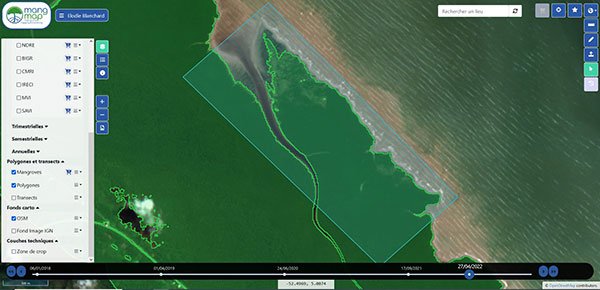
The platform is an interactive space for (1) consulting satellite imagery, (2) manipulating spectral indexes and (3) custom geo-information production services, at local scales.
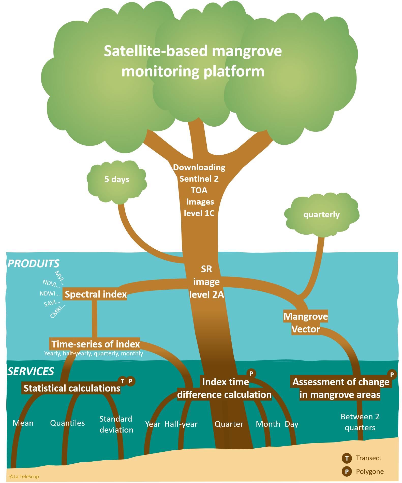
Based on the time series of optical imagery provided by the Sentinel 2 Constellation of the Copernicus Programme of the European Space Agency (ESA), the MangMap platform will be gradually enhanced with new families of imagery, new services for manipulating standardised spatial indices and new services for producing geo-information useful for characterising Mangroves.
With some twenty years' experience in characterising tropical coastal ecosystems by satellite in geographical areas of mangrove spatial distribution, the Unité Mixte de Recherche Espace-Dev has been leading the MangMap initiative since 2020.
The proposal for an operational satellite monitoring platform for mangroves, approved by the Space Climate Observatory, has resulted in a prototype financed by the IRD and the UMR Espace-dev, with support from the CNES. The development of the prototype was also supported by the GOLUM project, which brings together the IRD, the University of Montpellier and La TeleScop. The service provider chosen to develop MangMap is the Magellium company.
MangMap in its current version is an IRD software operated by UMR Espace-dev and deployed in its physical infrastructures at the Montpellier Data and Services Centre (CDS), under construction within the collaborative frameworks proposed by the Theia Land Data Center and the National Infrastructure Data Terra.
The platform is a tool for producing knowledge and building skills using satellite resources, but it is also a tool for scientific cooperation projects, to be co-constructed with those involved in developing the use of Earth observation in the South.
Objectives
Improve knowledge of the state and dynamics of mangroves to inform public restoration and conservation policies.
Provide standardised, reliable, up-to-date and easily accessible information on the state of mangroves and their current dynamics.
MangMap offers a complementary approach to existing tools and products:
- It provides local scales interactive monitoring tools, through an enduser dashboard dedicated to the production of spatial information useful for monitoring mangroves.
- It offers online services triggered on user demand, based on standardised products produced continuously with Sentinel 2 time series at 10 m resolution, renewed every 5 days.
- It is free and opened to user driven design & evolutions, co-lead with partners in Southern countries in charge of Mangrove knowledge and monitoring.
On the MangMap sites selected, the platform enables the following products to be viewed online and downloaded:
- Sentinel 2 level 2A satellite images, 13 spectral bands in visible light and near infrared with spatial resolution between 10 and 60 metres, updated every 5 days,
- 11 spectral indexes, raster format, 10 m spatial resolution: NDVI, NDWI, NDWI2, MNDWI, MNDWI2, NDRE, BIGR, CMRI, IRECI, MVI, SAVI calculated for each new Sentinel2 L2A image,
- Mangrove contour vector, proposed every quarter,
- Temporal composites for the 11 spectral index rasters :
- monthly
- quarterly
- half-yearly
- yearly
The platform offers services that users can request: launch calculations in their own zone of interest, downloaded or digitized on screen (polygon or transect), for a chosen period of time.
- Calculate differences from date to date or between temporal composites of indexes.
- Statistics calculation: changes over time in index values (mean, quantiles and standard deviation)
- Vector difference calculation: estimation of the spatial evolution of the mangrove between 2 dates.
All products viewed, manipulated or calculated on the platform are freely downloadable.
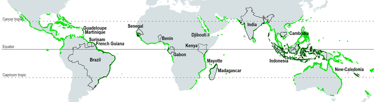
This first launch of MangMap in Demo mode is centred on 3 sites: Madagascar (Bombetoka Bay), New Caledonia (West Coast of North Province) and Djibouti (East Coast of Obock District).
The 16 sites that will form the platform's first geographical expansion are spread across South America, Africa, Asia and Oceania: French Guiana, Martinique, Guadeloupe, Mayotte, New Caledonia, Suriname, Madagascar, Gabon, Benin, Kenya, Djibouti, Senegal, Brazil, Cambodia, India and Indonesia.